County map shows zip codes of COVID-19 cases
Published 12:22 pm Friday, March 27, 2020
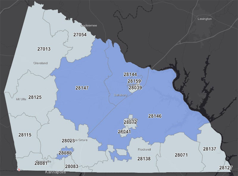
- This map, created by county government, shows where there are confirmed COVID-19 cases.
SALISBURY — On the same day as Rowan County saw its first COVID-19 death, Rowan County released a map of the 14 local COVID-19 cases by zip code.
On Friday, the county released more data about local cases in the form of a map showing the 28147 zip code, which is in the Salisbury area, had five people with COVID-19. That was the highest of any zip code in the county.
Other cases are as follows:
• Four cases in the 28144 zip code — in the Salisbury area.
• Two confirmed cases in the 28146 zip code, which includes parts of Salisbury and some of the eastern and southern parts of the county.
• Two confirmed cases in the 28088 zip code — in the Landis Area.
• One confirmed case in the 28159 zip code — in the Spencer area.
Other zip codes in the county do not yet have a resident with a confirmed case of COVID-19.
As of Friday, there were at least 763 cases of COVID-19 in the state and four deaths, including one in Rowan.
The map is available by using the following link: rowancountync.maps.arcgis.com/apps/opsdashboard/index.html#/a76ba21fff6e453d93ff20c3d70ed691
Health care professionals and county staff urge people who suspect they have symptoms of COVID-19 — cough, fever, tiredness and difficulty breathing — to contact their personal doctor or the Rowan County Health Department via its coronavirus hotline at 980-432-1800 to inquire about testing