Rowan weather: Hurricane Hermine will bring some rain
Published 7:52 am Thursday, September 1, 2016
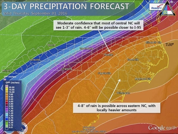
- NC Emergency Management Despite some changes in the forecast track of Tropical Storm Hermine, we can still expected heavy rain and localized flooding across central and eastern North Carolina. Gusty winds and tornadoes will also be possible across eastern NC. Greatest impacts to #ncwx look to be Friday PM - Saturday AM.
Hurricane Hermine could bring us a very wet Friday, but it all depends on the storm’s track.
In addition, there is a cold front moving over our area tonight that could prompt some severe thunderstorms with locally heavy rainfall and damaging winds.
The combination of the cold front and the tropical storm could lead to training of heavy rain along the front, which leads to the possibility of flash floods. Keep an eye on the weather for possible warnings tonight or tomorrow.
Showers and thunderstorms are likely tonight, with a 60 percent chance of rain. It will be mostly cloudy with a low of 67. North wind will blow around 6 mph before calming.
The chance of rain Friday is also 60 percent, with accumulations up to a half inch. Thunderstorms are possible after 2 p.m. It will be cloudy, with a high of 75. Northeast wind will blow at 8-11 mph, with gusts up to 18 mph. Another half inch of rain is possible.
Friday night’s chance of showers and thunderstorms is 80 percent, The low will be 64, with winds from the north northeast at 9-15 mph, gusting as high as 24 mph. As much as an inch of rain is possible.
But Saturday, skies will be partly sunny with a high of 80. Winds will blow from the north at 10-14 mph, with gusts as high as 24 mph. Saturday night will be clear and 61.
Sunday will be much calmer, with sunny skies and a high of 82. The low will be 62.
Labor Day will be sunny and the heat will increase, with a high of 86. The low will be 64.
For Tuesday, expect more sun and a high of 88, with a low of 67.
Wednesday will be sunny and we’re back to 90 for a high. The low will be 69.
Thursday will be mostly sunny and 92.