Emergency Services shares winter storm warning
Published 8:19 am Thursday, January 21, 2016
A message from Frank Thomason, director of emergency services for Rowan County:
Urgent – Winter weather message
National Weather Service -Rowan-
A winter storm warning will become effective tonight at midnight and extend through 7 pm Saturday, for a wintry mix of freezing rain…sleet…and snow. The winter storm watch is no longer in effect.
* Locations…the northern Piedmont of western North Carolina including Rowan County.
* Local hazards… A significant round of freezing rain and snow will start tonight and continue into Saturday.
* Timing… The winter storm will impact the area from this evening through Saturday night.
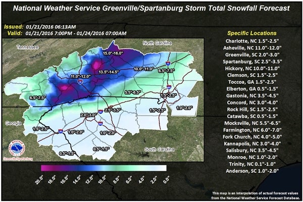
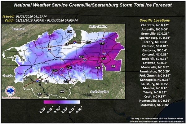
* Local accumulations…snow accumulation of 3 to 6 inches…along with around one quarter to one third of an inch of ice across the county with lower amounts to the southeast and higher amounts in the northwest.
* Local impacts… Snow and significant ice accumulation could make travel dangerous Thursday night through Saturday… And could combine with gusty winds to result in power outages.
* Winds…northeast 5 to 15 mph with gusts up to 25 mph.
* Temperatures…in the upper 20s to around 30 degrees.
Precautionary/preparedness actions…
A winter storm warning means significant amounts of snow, sleet and ice are expected occurring. Strong winds are also possible. This will make travel very hazardous or impossible.
Current operations level of Rowan County emergency operations center: level 4 – monitoring conditions.