Winter weather watch includes snow, sleet, freezing rain
Published 12:00 am Monday, February 10, 2014
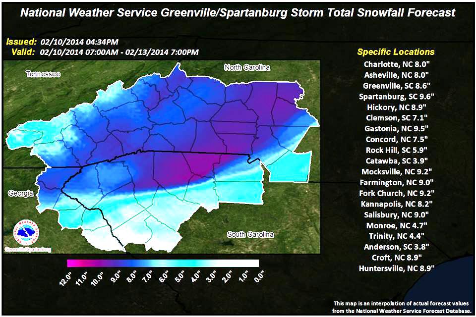
UPDATE: Current forecasts indicate a significant increase in predicted snowfall from this morning for Rowan County to between 7 and 9 inches. Ice accumulations are shown in the attached graphic to the eastern half of the county and amounts around 1/10 inch or less. See attached graphics.
While some flurries and rain will continue across the area on Tuesday, the most significant snowfall will begin on Wednesday morning and extend through Thursday morning.
The Winter Storm Watch for the county will go into effect as previously outlined at 6 p.m. today. It is likely this Watch will be upgraded to a Warning as we move closer to the larger Wednesday event.
The Rowan County Emergency Operations Center will move to a Level 4 Alert Status (Core EM personnel are on duty and monitoring changes in situation or conditions. All countywide agencies are notified of changes in conditions by email, pagers or radio broadcasts from EM Staff. EOC is not activated) at 6 p.m. today as well.
Additional information will be provided as needed.
Frank Thomason, chief of emergency services for Rowan County, earlier issued this winter weather message from the National Weather Service:
…WINTER STORM WATCH IN EFFECT FROM 6 PM TUESDAY EVENING THROUGH 7 AM THURSDAY MORNING…
* LOCATIONS…NORTHWEST PIEDMONT OF WESTERN NORTH CAROLINA INCLUDING ROWAN COUNTY.
* HAZARDS…HEAVY SNOW…POSSIBLY MIXING WITH SLEET AND FREEZING RAIN OVER THE PIEDMONT.
* TIMING…SNOW WILL LIKELY DEVELOP FROM THE SOUTH TUESDAY NIGHT AND THEN INCREASE IN INTENSITY WEDNESDAY INTO WEDNESDAY NIGHT. SLEET AND FREEZING RAIN MAY MIX IN ACROSS PIEDMONT SECTIONS STARTING LATE WEDNESDAY. PRECEEDING THIS EVENT, THERE WILL BE A CHANCE OR SLIGHT CHANCE FOR SOME INITIAL SNOWFALL THROUGHOUT MONDAY AND TUESDAY, WITH NO APPRECIABLE ACCUMULATION CURRENTLY FORECAST.
* ACCUMULATIONS…SNOW ACCUMULATIONS OF 4 TO 6 INCHES IN THE PIEDMONT. ICE ACCUMULATIONS OF A TRACE TO ONE TENTH OF AN INCH IN THE PIEDMONT.
* IMPACTS…THE HEAVY SNOW…WITH SLEET AND FREEZING RAIN MIXING IN AT TIMES…WILL MAKE TRAVEL TREACHEROUS. THE ACCUMULATIONS MAY ALSO CREATE POWER OUTAGES…ESPECIALLY WEDNESDAY THROUGH WEDNESDAY NIGHT.
* TEMPERATURES…MOSTLY IN THE UPPER 20S TO AROUND 30.
* WINDS…NORTHEAST 10 TO 15 MPH WITH GUSTS UP TO 25 MPH.
PRECAUTIONARY/PREPAREDNESS ACTIONS…
A WINTER STORM WATCH MEANS THERE IS A POTENTIAL FOR SIGNIFICANT SNOW…SLEET…OR ICE ACCUMULATIONS THAT MAY IMPACT TRAVEL. CONTINUE TO MONITOR THE LATEST FORECASTS. STAY TUNED TO NOAA WEATHER RADIO OR YOUR FAVORITE SOURCE OF WEATHER INFORMATION FOR THE LATEST UPDATES.