Survey team uses radar to investigate caved-in area near Gold Hill mine
Published 12:10 am Saturday, May 30, 2015
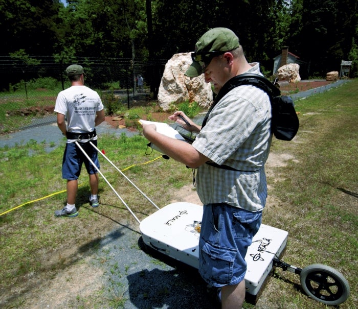
- JON C. LAKEY / SALISBURY POST Daren Nelson, assistant professor in the Department of Geology and Geography at UNC Pembroke, takes notes before assistant Jase Ritchie prepares to drag a ground-penetrating radar over the area of study. On Friday, researchers and geologists used radar to determine how widespread a collapsed depression was near the Gold Hill Village.
By Mark Wineka
mark.wineka@salisburypost.com
GOLD HILL — Jase Ritchie, a 2012 graduate of East Rowan High and rising senior at the University of North Carolina at Pembroke, was part mule, part geologist Friday afternoon.
Ritchie was strapped to a lightweight cart, whose ground-penetrating radar was sending back information to the monitor of geology professor Daren Nelson, who was following behind Ritchie.
The men were making back-and-forth passes across a grid set up in Gold Hill Mines Historic Park. Central to that grid was a sizable hole — one that for safety purposes has been fenced in since last November.
Now about that hole.
When a magnitude 4.1 earthquake hit close to Edgefield, S.C., the night of Feb. 14, 2014, folks from Georgia to North Carolina reported feeling some of the vibrations.
The earthquake actually left a mark in Gold Hill.
The tremors led to a cave-in of ground in the Gold Hill park along St. Stephen’s Church Road (Main Street in the old village), and with aftershocks a day later, the hole broadened and deepened.
Board members of the Historic Gold Hill and Mines Foundation Inc. arranged with nearby Vulcan Materials to provide four truckloads of fill material for the collapsed area, and the spot seemed to be stabilized until another tremor in November 2014 opened the hole again.
When it was all said and done, the foundation dumped 200 tons of fill material into the cavity but could not close it.
“So we decided we better fence it,” Vivian Hopkins, vice president with the foundation board, said Friday.
Since then, the hole has been measured at 125 feet deep.
The fenced-in area lies in the middle of a memorial garden Scouts were hoping to create in remembrance of all the miners who had worked in Gold Hill. It’s located between Gold Hill United Methodist Church and the old assay office and post office buildings.
The collapsed area has puzzled foundation board members, Hopkins said, because historic maps of the mining operations in Gold Hill did not show any tunnel or shaft from the Randolph mine coming to a point this far. Hopkins could only theorize that maybe this caved in area had been a shaft for men and equipment to gain access to a section of the Randolph mine.
Phil Bradley, assistant section chief and Piedmont geologist for the N.C. Geological Survey, gave a report to the foundation board this past winter that characterized the hole as either a cave in or collapse that probably was “due to excavations associated with the center vein.”
If that was the case, Bradley added, more collapses could occur “along the trend of the center vein northeast to southwest.”
Bradley also theorized the hole was connected to “workings” not documented on the historic maps. He recommended additional investigations in this area because the collapsed areas pose “a potential serious threat to visitors and pedestrians.”
Part of that additional investigation has been happening this week, thanks to administration, faculty and students from UNC-Greensboro and UNC-Pembroke.
The team included Ritchie; Nelson, assistant professor of geology at UNC-P; Dr. Lee Phillips, director of the Undergraduate Research, Scholarship and Creativity Office at UNC-G; UNC-G student Harrison Bolton; and Dr. Roy Stine, a UNC-G associate professor who specializes in remote sensing and geographic informations systems.
They were using ground-penetrating radar to look for any near-to-the-surface disturbances — openings or voids — that might pose or indicate dangers down the road to park visitors. Phillips and some students had been in Gold Hill in October 2013 doing similar research.
The team concentrated on areas mainly around the Barnhardt and Randolph mines, including the collapsed area triggered by the February 2014 earthquake. Friday afternoon, the researchers set up a grid pattern around that hole and used two ground-penetrating radar devices — one 100 megahertz; the other, 200 megahertz.
The GPR essentially sends down a radio signal, and the geologists collect information from the two different frequencies.
The 100-megahertz GPR goes 8 to 9 meters deep, while the 200-megahertz GPR goes about 2 to 4.5 meters deep with its signal but provides more detail.
Phillips said the exercise gives students an opportunity to work in the field, collect data, interpret the data and ultimately give presentations on their findings — all of which will enhance their research and communications skills.
Meanwhile, the foundation doesn’t have to pay for valuable information it needs to make sure the park is safe.
“You can’t beat the price,” Phillips said.
Hopkins couldn’t have agreed more. “It’s a great opportunity for them and a huge opportunity for us,” she said.
The team will report its findings at a later date.
Contact Mark Wineka at 704-797-4263.